
AirIPR system: Airborne Ice-Penetrating Radar
Background
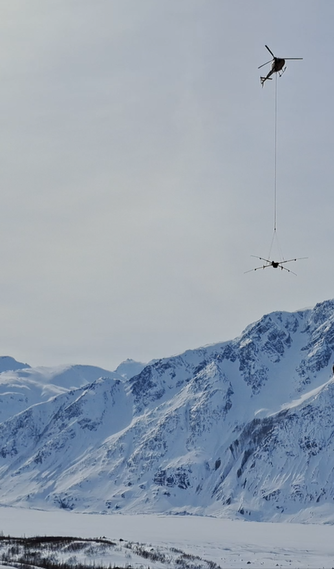
 Photo Credit: Kim Flament
Helicopter-based radar surveys bridge the gap between two well-established radio-echo sounding methods: airplane-based and ground-based surveys.
Airplane-based surveys can cover extensive geographical areas but often lack tight maneuverability. This limitation typically confines them to high-elevation flights and longitudinal glacier transects, resulting in data issues with valley walls and off-nadir bed reflections.
Ground-based surveys, conducted on foot, skis, or snow machines, are precise in specific terrains but are inherently slow and limited by surface conditions and terrain.
Given that all these techniques are complementary, helicopter-based surveys offer a valuable solution to the challenges mentioned above. They provide an efficient strategy for covering extensive terrain unsuitable for fixed-wing or ground surveys, provided that flying conditions are favorable (e.g., good visibility and minimal wind).
In this context, AirIPR offers a new, field-proven, operational airborne ice-penetrating radar system to deliver Surveys as a Service (SaaS). Data produced by the system can supports water resource management, glacier flow modeling, melt models, and natural hazard assessment. Additionally, the radar data provides insights into englacial properties and other characteristics detailed in radio-glaciology literature.
System - Standard AirIPR
|
Based on the roving & stationary IceRadar IPR (and sIPR) implementations [1], [2] , the standard AirIPR system comes with enhanced onboard software for airborne operation, integrating radar data with additional hardware data source(s) such as an AGL system that provides above-ground elevation measurements. The AGL, also plays a critical role in providing elevation information to the helicopter pilot, with a dedicated wireless display located inside the cockpit.
(*): better resolution is attainable considering some upper frequency present in the radar pulse. Radar being interpretive, there will be data sections where the bed determination will not be well defined. In these case, vertical resolution will be less. |
Operation
|
|
Data Example
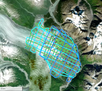
Tweedsmuir Glacier, Tatshenshini-Alsek Provincial Park, BC, Canada, Traditional territory of The Champagne and Aishihik First Nations.
Processing to enhance bed at ~ 600m
Processing to enhance bed at ~ 600m
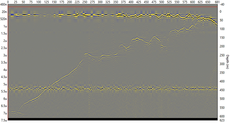
Grand Pacific Gl. Tatshenshini-Alsek Provincial Park, BC, Canada. Traditional territory of The Champagne and Aishihik First Nations.
Processing to enhance bed at ~ 600m
Processing to enhance bed at ~ 600m
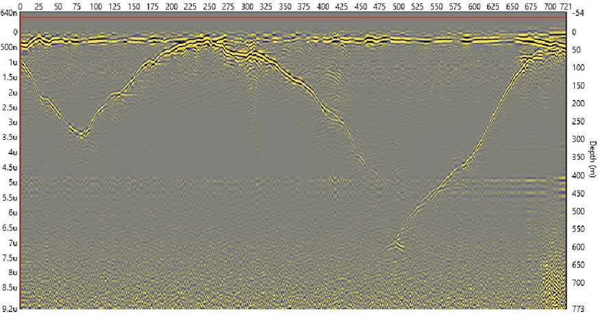
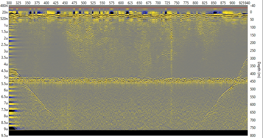
Kaskawulsh Gl., Kluane National Park, Yukon, Canada. Traditional terrirory of Kluane First Nation.
Disappearing bed around 700-750m with experimental Tx
Disappearing bed around 700-750m with experimental Tx
SaaS : Surveys as a Service

- Surveys planning and logistics
- Surveys execution with latest AirIPR system hardware & carrying platform, redundant hardware
- Data pre-processing & post-processing
- Data products as xy-z (depth) files with or without 3D bed rendering
References
- [1]: Mingo, L., & Flowers, G. (2010). An integrated lightweight ice-penetrating radar system. Journal of Glaciology, 56(198), 709-714.
- [2]: Bigelow, D. G., Flowers, G. E., Schoof, C. G., Mingo, L. D. B., Young, E. M., & Connal, B. G. (2020). The role of englacial hydrology in the filling and drainage of an ice-dammed lake, Kaskawulsh Glacier, Yukon, Canada. Journal of Geophysical Research: Earth Surface, 125, e2019JF005110.
- [3] https://www.jostice.no/airborne-ice-radar-2022.html